
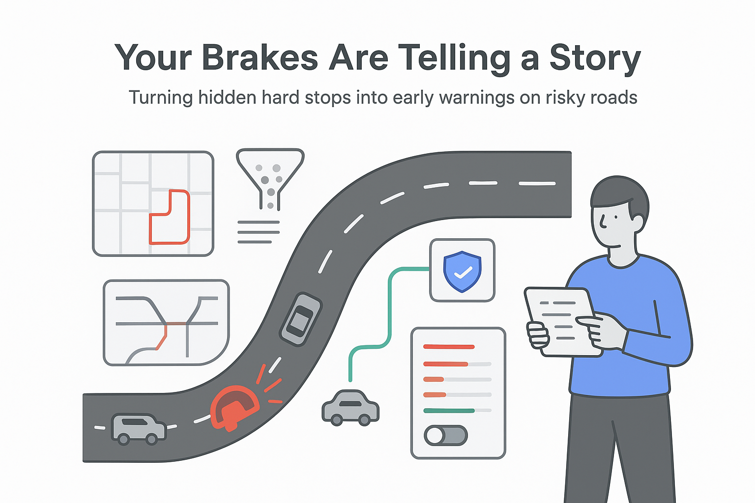
Hard-braking events as a leading indicator of road segment crash risk
Hard-braking data from the Android Auto platform offers a denser, earlier signal of dangerous road segment risk than traditional crash reports. Google and Virginia Tech report a strong, statistically controlled link between hard-braking frequency and crash rates in California and Virginia over a 10-year period [S1][S2].
Executive snapshot: hard-braking events and crash risk
- Road segments with observed hard-braking events (HBEs, defined as forward deceleration worse than -3 m/s²) were 18× more numerous than segments with a reported crash in the same period across California and Virginia, giving far broader network coverage than police reports alone [S1][S2].
- Using negative binomial crash models that control for exposure (traffic volume, segment length) and road features (type, slope, turning angle, ramps, lane changes), higher HBE rates are statistically associated with higher crash rates across both states and across local, arterial, and controlled-access highways [S1].
- A California freeway merge segment connecting Highways 101 and 880 showed an HBE rate about 70× higher than the state freeway average, ranked in the top 1% of all segments for HBEs, and recorded roughly one crash every six weeks for a decade [S1].
- Segments containing ramps were positively associated with crash risk in both states, aligning with known risks from weaving and merging behavior [S1].
Implication for marketers and operators: road risk can now be assessed earlier and at higher resolution using connected-vehicle hard-braking data, which affects how fleets, locations, and mobility-related services are planned and marketed.
Method and source notes on hard-braking safety data
Google Research's Mobility AI team, in collaboration with Virginia Tech, evaluated HBEs as a leading indicator of crash risk using connected-vehicle data from Android Auto and public crash data from Virginia and California [S1][S2].
What was measured
- Outcome variable: Police-reported crashes (any severity) at the road segment level over roughly 10 years (2016-2025), based on public state crash databases from Virginia and California [S1][S3][S4].
- Primary predictor: Rate of hard-braking events, defined as instances where forward deceleration exceeded -3 m/s², interpreted as evasive maneuvers rather than routine slowing [S1]. HBEs were aggregated and anonymized from Android Auto users [S1].
- Controls:
- Exposure: segment length, traffic volume [S1].
- Infrastructure: road type (local, arterial, highway), slope, cumulative turning angle [S1].
- Dynamics: presence of ramps, changes in the number of lanes [S1].
Modelling approach
- negative binomial regression models were used, a standard crash-modelling approach in the Highway Safety Manual (HSM) to handle overdispersed crash counts [S1][S5].
- Separate models were estimated for California and Virginia, and the relationship between HBE rate and crash rate was examined across road types [S1].
Key limitations and caveats
- Geography: Only two U.S. states were analyzed; results may not generalize to other regions or driving cultures [S1].
- Sample coverage: HBEs come only from Android Auto-active vehicles. Penetration by region, vehicle type, and driver demographics is not reported, so coverage bias is possible [S1].
- Data granularity: HBEs are treated as segment-level signals. The study explicitly states it does not evaluate driver-level risk or behavior outside specific locations [S1].
- Effect size transparency: The blog summary reports statistical significance and directional effects, but not exact coefficients (for example, crash-rate increase per additional HBE), which limits quantitative risk scoring from this summary alone [S1].
Key findings on road segment risk and hard-braking events
Data density versus crash records
Traditional crash records are sparse, especially on local and lower-volume roads where a segment may take years to accumulate a single reportable crash [S1][S6]. HBEs occur far more frequently and across many more segments:
- Across California and Virginia, road segments with at least one observed HBE were 18× more numerous than segments with at least one reported crash over the 10-year window [S1][S2].
- This higher density means safety analysts can assign a risk signal to many segments that have no crash history yet, filling gaps where long-term collision data is missing [S1].
Interpretation (likely): For any application that depends on network-wide safety intelligence (road management, fleet routing, last-mile planning), HBEs function as a much richer coverage layer than crash reports alone, especially off major highways.
Statistical link between HBEs and crashes
The central question for the researchers was whether frequent hard braking is simply a sign of aggressive driving or random noise, or whether it is systematically related to crash risk when controlling for environment and exposure. The study reports that:
- In both California and Virginia, the estimated coefficient on HBE rate in negative binomial crash models is positive and statistically significant, meaning segments with more HBEs experience more crashes even after adjusting for traffic volumes, segment length, and road characteristics [S1][S2].
- This relationship holds within road-type categories: local streets, arterials, and controlled-access highways all show higher crash rates where HBE rates are higher [S1].
- The model also shows that certain infrastructure features, notably ramps, are associated with increased crash risk in both states, consistent with weaving and merging challenges [S1].
Interpretation (likely): HBEs clear a high bar as a surrogate safety measure: they are not only abundant but also systematically aligned with crash outcomes under standard highway safety modelling methods.
Case example: California freeway merge segment
To illustrate real-world use, the team highlights a freeway merge segment in the California Bay Area that connects Highways 101 and 880 [S1]:
- This single segment ranked in the top 1% of all road segments statewide by HBE frequency.
- It recorded an HBE rate about 70× higher than the average California freeway segment [S1].
- It experienced approximately one reported crash every six weeks for a decade [S1].
Despite needing years of crash data to confirm the risk statistically, the HBE signal alone was sufficient to flag the segment as an outlier early, based purely on connected-vehicle behavior [S1].
Interpretation (likely): For high-risk merges and similar complex geometries, HBE-based alerts can surface problematic locations well before traditional crash statistics accumulate enough volume to trigger concern.
From research to product
Google's Mobility AI team is integrating HBE-based safety layers into Roads Management Insights within the Google Maps Platform [S1]. This gives transportation agencies and partners:
- Aggregated, anonymized HBE data with higher spatial coverage than crash data.
- Data that is more recent than long-term crash statistics, enabling shorter feedback cycles for evaluating road changes [S1].
The blog notes that current results support road-segment risk assessment only, not driver risk profiling [S1].
Interpretation and implications for mobility and location-based businesses
This section synthesizes what the findings likely mean for business and marketing strategies. Each point is labeled by certainty level.
Likely implications
- Faster identification of risky access routes for physical locations. Businesses that depend on customer access by car (retail, logistics hubs, medical facilities) can, via partners or public agencies, use HBE-based maps to understand whether key approach roads or nearby merges carry elevated crash risk. That informs site selection, signage needs, and expected access reliability over time.
- More informed fleet routing and service promises. For delivery, ride-hailing, and field-service fleets, routing engines that incorporate HBE-based risk scoring can favor safer segments while still meeting time constraints. This can reduce collisions and related downtime, which then affects customer promises, SLAs, and the true cost of "fast delivery" marketing claims.
- Richer context for mobility-related B2B products. SaaS providers in telematics, insurance, and traffic analytics that build atop Google Maps Platform can plug in an empirically validated safety layer rather than designing a proxy from scratch, improving the credibility of their risk dashboards and reports for clients.
Tentative implications
- Media and location-based advertising planning. Offline and out-of-home media planners may consider segment-level crash risk, not just traffic volume, when choosing locations for billboards, drive-to-store campaigns, or roadside promotions. High-traffic but lower-risk corridors may be preferable from a brand-safety and liability perspective.
- Brand and CSR positioning around road safety. Firms with visible fleets (logistics, utilities, passenger transport) can work with agencies that use HBE-driven insights to prioritize engineering or educational interventions near their depots and major routes. This can support credible safety narratives backed by quantified data.
Speculative implications
- Influence on navigation, travel-time reliability, and user expectations. Over time, if HBE-rich segments are down-weighted in routing or flagged as risky, travel-time distributions for certain corridors may widen. Marketers who promise "under X minutes" experiences may need to revisit assumptions about route reliability in dense urban networks where HBEs are frequent.
- Insurance and pricing innovation. If insurers or mobility platforms adopt HBE-based road risk metrics, pricing might start to reflect not only driver behavior but also the risk profile of the roads a service depends on. That could feed into budgeting for delivery operations, franchise siting, or mobility subscriptions.
Across these areas, the main shift is that road safety intelligence becomes more like a continuous signal than a slow-moving statistic, which shortens feedback loops between changes on the ground and measurable outcomes.
Contradictions, gaps, and limits in the hard-braking dataset
Several open questions and limits are either stated or implied by the study summary:
- Generalizability beyond two U.S. states. The analysis covers only Virginia and California, which have distinct traffic patterns and infrastructure. There is no direct evidence yet that the same HBE-crash relationship holds in other states, rural regions with very low Android Auto usage, or non-U.S. countries [S1].
- Magnitude of the effect. While the association is statistically significant and positive, the blog does not publish model coefficients or elasticity estimates (for example, crash-rate change per standard deviation increase in HBE rate). Businesses cannot yet translate an observed HBE score into an expected crash-rate uplift from the summary alone [S1].
- Driver behavior versus infrastructure effects. HBEs can result from poor infrastructure, unexpected obstacles, weather, or aggressive driving. The study focuses on segment-level risk and explicitly avoids conclusions about driver behavior independent of location [S1]. For insurers or driver-scoring applications, this is a critical distinction.
- Coverage and bias in Android Auto data. No statistics are released on Android Auto penetration by geography, vehicle segment, age, or income. If certain groups underuse Android Auto, HBEs may underrepresent their experience, biasing segment risk estimates in some areas.
- Unmodelled factors. The blog does not describe controls for time of day, weather, or temporary disruptions (roadworks, events). These factors might influence both HBEs and crashes, leaving some residual confounding that more detailed modelling would need to address.
From a marketing and business-planning perspective, these gaps mean HBEs can be treated as a strong directional safety signal, but not yet as a sole quantitative target for contractual guarantees or pricing without additional, context-specific validation.
Sources
[S1] Arora, N., Li, Y., et al. "Hard-braking events as indicators of road segment crash risk." Google Research Blog, 13 Jan 2026.
[S2] Arora, N., Li, Y., Shahane, S., Vasserman, S., Osorio, C., et al. "From Lagging to Leading: Validating Hard Braking Events as High-Density Indicators of Segment Crash Risk." arXiv:2601.06327, 2026. (Paper).
[S3] Virginia Roads - Commonwealth of Virginia road safety and crash data portal.
[S4] California Crash Records System (CCRS) - State of California open crash data.
[S5] Federal Highway Administration. Highway Safety Manual resources.
[S6] Federal Highway Administration. "Handbook for Designing Roadways for the Aging Population, Chapter 4 - Roadway Segment Design."


.svg)

.svg)
.svg)